
please remember you can click on a photo to see a larger version & highlighted text are links to additional information
Maps, Hikes, and Discovering History
Note: Be forewarned, there will be a lot of detail in this blog post. This is meant to inform rather than entertain, as if I am capable of either ;).
This adventure began with an airplane crash. Several years ago, as I was researching historic plane crash sites in our nearby mountains, I came upon this local newspaper article.
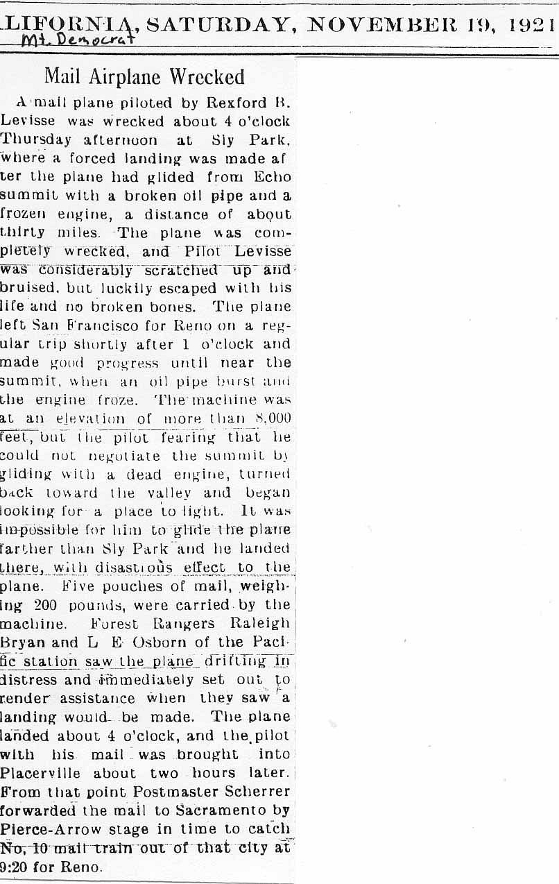
One piece of information leads to another. In this case it led to interest in the early air mail pilots.
And that led to interest in the early air mail routes across the United States and the birth of the Transcontinental Airway System.
The first airway system route
stretched from New York City to San Francisco.
Night flights along portions of the route began on July 1, 1924.
Navigation aids for night flying - lighted airway beacon towers - were erected
along the route. Placement of lighted airway beacons in Nevada began in the
summer of 1928.
Reno Gazette article 31 July 1928
Here is a link to a short history of the U.S. Airmail Beacon System.
Concrete Arrows and the U.S. Air Mail System
The original route of the airway across Nevada was along the Humboldt River and the original Transcontinental Railroad - now Interstate 80. A shortcut for the route was developed in 1930 that made a shorter straight line over rugged terrain from Fernley to Beowawe. A notice of discontinuance of the beacons along the old route was published in the Jul - Jun 1930-1931 Air Commerce Bulletin.
It was the beacons along this remote area of Nevada that interested us, because this is the kind of terrain we love - vast, unpopulated, rugged. We made several trips to discover what remained, if anything, of these historic U.S. Air Mail Airway Beacons from Fernley to Beowawe.
First we needed information on the beacons and the locations.
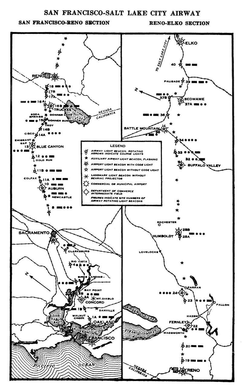
Even better was the actual air navigation chart from the Library of Congress for the route -
Air Navigation Map No. 34 Elko to Reno, NEV.
The initial infrastructure for a lighted airway route was a lighted beacon tower every 10 miles and an emergency landing field every 25 to 30 miles. As the maps show, the system evolved beyond this. The standard airway beacon was of this design -
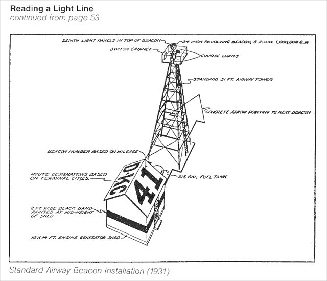
It consisted of a lighted beacon tower, a painted concrete arrow pointing the way, a generator building and generator to power the electric lights. On the map legends above, this type of beacon is indicated by a red star with an open center and two red arrows - "Airway light beacon, rotating (Arrows indicate course lights)"
The emergency landing fields - Department of Commerce Intermediate Landing Fields (DOCILF) on the maps are indicated by a red circle with four short outward red dashes.
The more developed DOCILF's had a lighted beacon tower that the map legend identifies with a red star with open center with five red dashes between the star points - "Airport light beacon with code light (within airport symbol)"
A third type of airway beacon is also
shown on the maps with a solid small red star - "Auxiliary airway light
beacon, flashing".
A little about beacon numbering. The standard beacon numbers were designated as if they were each 10 miles apart. Beacon number 8 on the San Francisco/Salt Lake City route was located (nothing remains) in downtown Roseville, California 80 air miles from the start at San Francisco. Beacon 10 is still standing at the Auburn, California Airport 100 air miles from San Francisco. Beacon number 22 once stood at the Fernley, Nevada DOCILF (Department of Commerce Intermediate Landing Field), 220 air miles from San Francisco. The auxiliary beacons were numbered with the miles from San Francisco.
So there were four things we were searching for - the landing fields, the landing field beacons, the standard (course light) beacons, and the auxiliary beacons.
Where were they located? The maps noted above are very large scale and provide minimal information on actual location on the ground. We turned to maps, especially historic USGS topographic maps. Another source was historic Department of Transportation maps from the state of Nevada. These all would prove to be very interesting in helping to piece together the puzzle.
Here is what we found - and will continue to search for - out in this remote expanse of Nevada. I invite you to continue to refer back to the Air Navigation Map no. 34 from the Library of Congress.
Note - to protect what remains at
these historic sites, I will not give details for locations beyond the obvious.
There are several that remain for us to
search for. This post will be updated as we do. If anyone finds and visits a beacon site, please do not take or disturb anything that remains.
Beacon 216 (auxiliary beacon, flashing) - date of visit 15 March 2015
We will start with Beacon 216 on the western edge of Fernley. This is one of the most intact auxiliary beacons remaining. As with many of the remote auxiliary beacons, this beacon was powered by acetylene gas. It sits high on a ridge.
Note the anchor points and construction details as it will be very helpful at other sites.
The number 216 is barely visible on opposite sides of the beacon. This was the only visible number we found on any of the auxiliary beacons.
Scattered on the ground were fragments of the broken heavy glass lenses.
Fernley DOCILF and Beacon 22 (Airport light beacon with code light) - date of visit 15 March 2015
From the Airway Bulletin no. 1-2. 1931-1938
"Department of Commerce intermediate field, site 22, San Francisco Salt Lake Airway. Two miles NE. Altitude , 4,159 feet. Diamond shape, 129 acres, 2,600 by 2,500 feet, sandy, level, natural drainage. Directional arrow marked "22 SF-SL." Beacon tower in SW. corner. Beacon, boundary, and approach lights. Beacon, 24 - inch rotating, with green course lights flashing characteristic "2" ( . . - ). No servicing facilities. Teletype."
The Fernley Intermediate Landing
Field was just to the east of Fernley. The landing field, now along Interstate 80, is
now a large industrial site with distribution hubs for large companies.
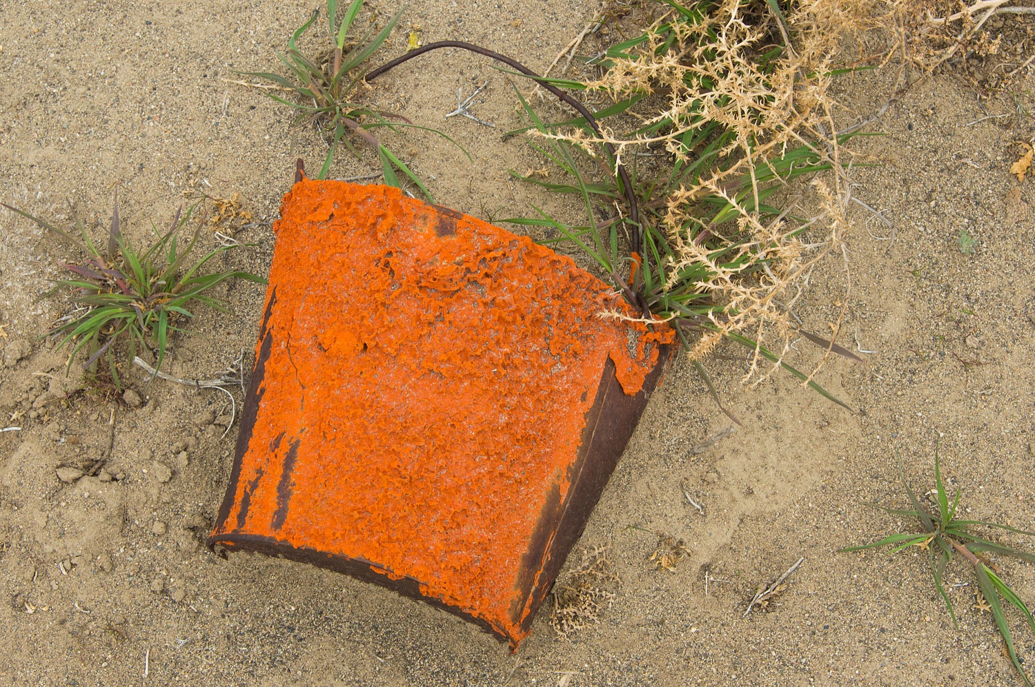
Little, if anything remains of the landing field. During our search of the area, all we found was an
old rusty bucket of the familiar orange paint we found on many of the beacons. The site of Beacon 22 has been destroyed with the construction of Interstate 80.
I suspect that the beacon tower was moved to the small airfield to the south of Fernley where it still stands.
Beacon 229 (auxiliary beacon,
flashing) - a future search
This one is on the "to do" list for a future trip. Its location is shown on a historic large scale USGS topo map.
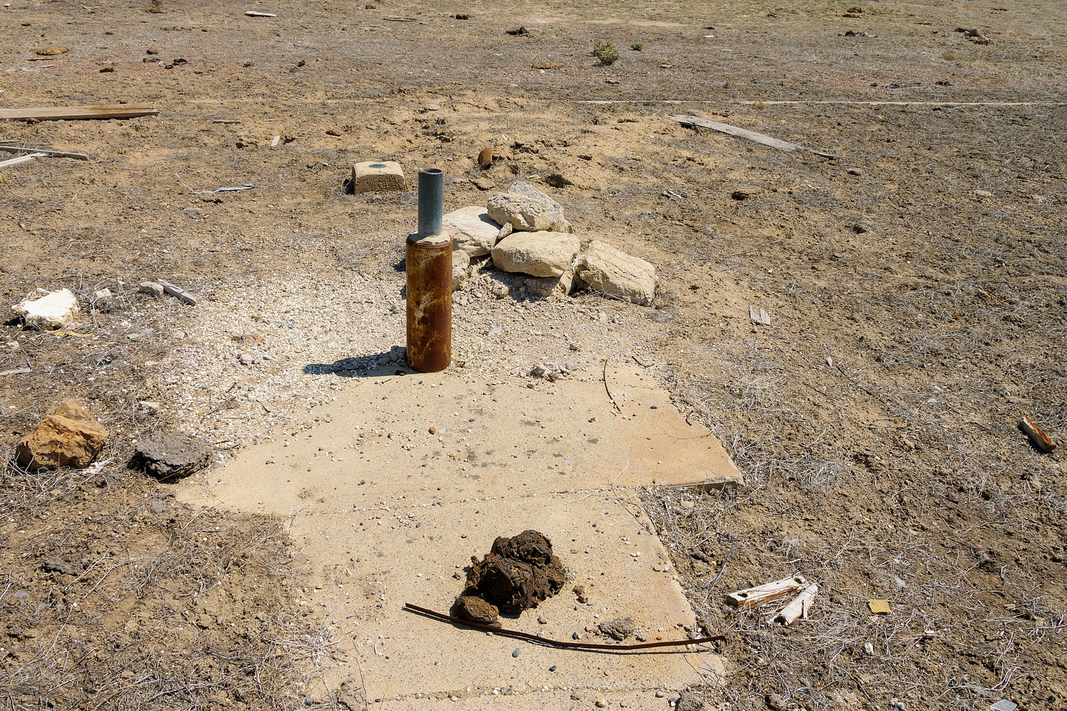
Beacon 23 (Airway light beacon, rotating) - 14 March 2015
From Air Commerce Bulletin Vol.2 No.15 Feb. 2, 1931
SF-SL site No. 23B — A 24-inch beacon light, 1,000,000 candlepower, showing 6 rotations per minute, is in operation at this site. Two red course lights flash characteristic: Dot, dot, dot (...) The beacon light is mounted on a 51-foot tower which is painted yellow and black. The concrete arrow has been painted yellow with numerals on the tail.
This beacon site is on a long ridge.
This was a standard airway beacon,
run by a generator, with course lights. Not much remains besides a concrete pad
and pieces of broken lights. It may have had a concrete arrow. Pieces of
concrete have been pushed down slope. Note the anchoring system for the tower.
Parran DOCILF and Beacon 24 (Airway light beacon, rotating) - 14 March 2015
From the Airway Bulletin no. 1-2. 1931-1938
"Parran. - Department of Commerce intermediate field, site 24, San Francisco Salt Lake Airway. Four miles W. of city. Altitude, 4,000. Irregular shape, 182 acres, 3,200 feet E./W., 3,400 feet N./S., 4,400 feet NE./SW., sandy loam, rolling, natural drainage. Directional arrow marked “ 24 SF-SL." Pole line to W., beacon tower in NW. corner. Beacon, boundary, approach, and obstruction lights. Beacon, 24 - inch rotating, with green course lights flashing characteristic “4” ( . . . . ). Emergency supply of aviation fuel."
All that we found at this site was a crumbling concrete pad.
Beacon 243 (auxiliary beacon,
flashing) - a future search
Another beacon on the "to do" list. It is only found on the Air Navigation Map, not found on any topo map I've seen.
Beacon 25 (beacon type unknown) - a future search
This beacon site is puzzling. It is not shown on the Air Navigation Map but it is shown on a historic Nevada DOT map and labeled "Beacon 25". The location is also shown on a historic topo map - "Airway Beacon". We will search for this site.
Beacon 253 (auxiliary beacon, flashing) - 14 March 2015
Very little remains at this beacon site on the northern edge of the Carson Sink.
We found one anchor rod and a few scraps of metal and glass fragments.
A surprise, about 100 yards away we found a benchmark labeled "beacon 253" from 1935.
Beacon 263 (auxiliary beacon,
flashing) - future search
This beacon site is a long ways out, north of the Carson Sink.
Unknown Beacon - a future search
This is another puzzling beacon site. It's location is indicated as an "Airway Beacon" on a historic topographic map from 1931 but on no other source, including the Air Navigation Map. We will search for it on a future trip.
Beacon 28A (Airway light beacon, rotating) - 8 March 2015
From Air Commerce Bulletin Vol.2 No.15 Feb. 2, 1931
SF-SL site No. 28A — A 24-inch beacon light, 1,000,-000 candlepower, showing 6 rotations per minute, is in operation at this site. Two red course lights flash characteristic: Dash, dot, dot, dot ( ...). The beacon light is mounted on a 51-foot tower which is painted yellow and black. The concrete arrow has been painted yellow with numerals on the tail.
This was a classic airway beacon with a concrete arrow. The concrete pad and arrow are still intact. Little else remains except for broken fragments of electrical components.
Beacon 28B (Airway light beacon, rotating) and Humboldt DOCILF - 15 April 2021
From the Airway Bulletin no. 1-2. 1931-1938
"Humboldt. Department of Commerce intermediate field, site 28B, San Francisco-Salt Lake Airway. Eighteen miles SE. of Lovelocks, 4 miles SE, of Humboldt Range. Altitude, 4,155 feet. Triangular, each side measures 3,500 feet, sod and dirt, level, natural drainage. Shed roof marked “28B SF-SL.” Pole line to NW. Code beacon, boundary, approach, and obstruction lights. Code beacon, green, flashing characteristic “8” ( . . . ) on field. Beacon, 36 - inch rotating, flashing green and white on ridge 1 mile Sw. of field. Aviation fuel No other servicing facilities Teletypewriter. Marker beacon nondirective characteristic signal “I” ( . . ), operating frequencies 391 and 278 kc."
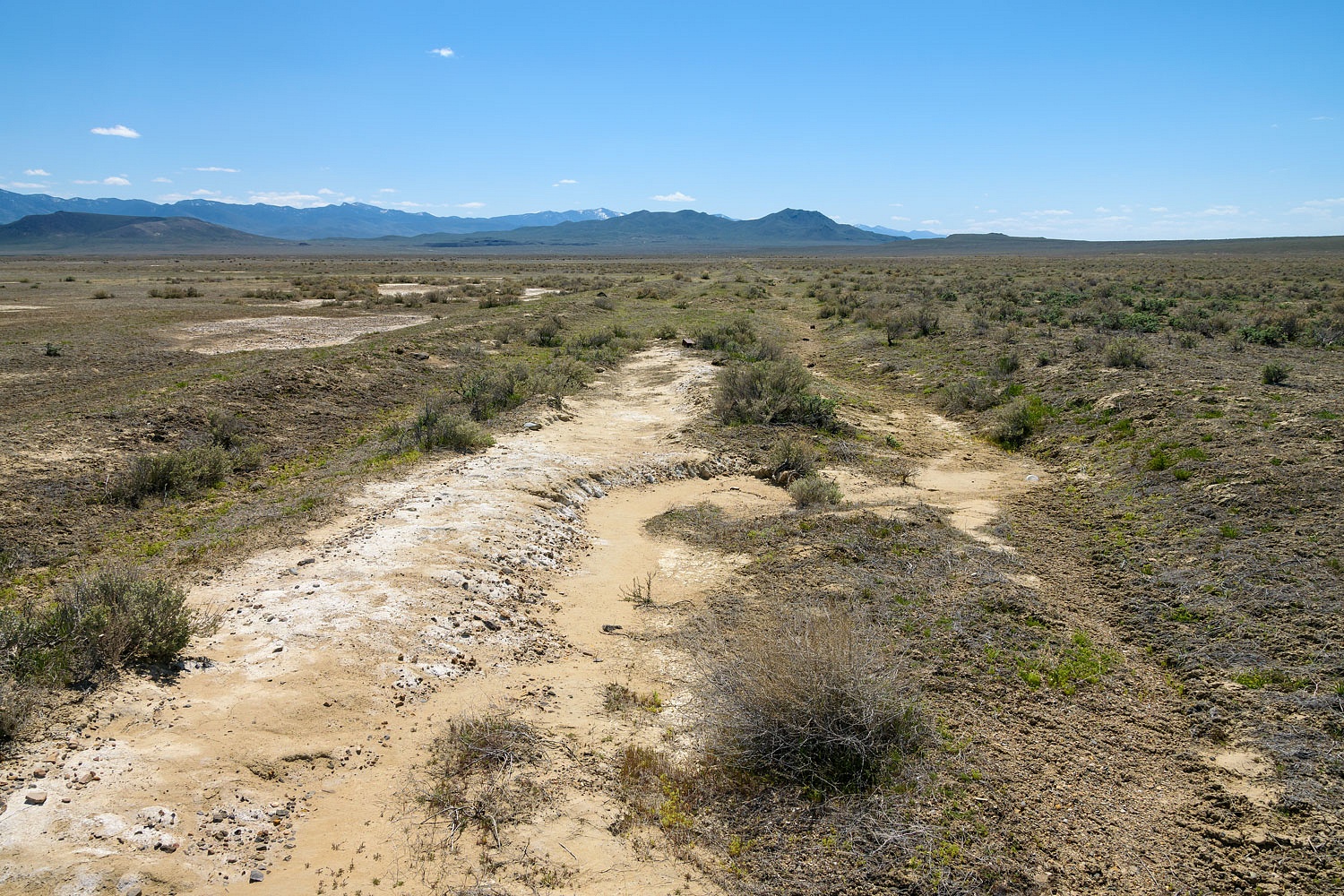
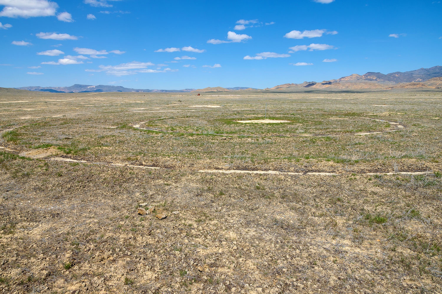
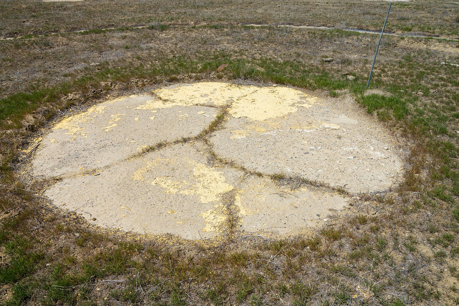
This DOCILF is located on a broad flat plain on the south end of Buena Vista Valley. We found no evidence of the beacon. There were a few foundations that we believe were associated with buildings at this emergency airfield. There was debris and junk on site from more recent mining activity in the area.
This Intermediate Landing Field shows up on satellite images as a large triangle. The triangle was made by plowing a lower perimeter around the field - perhaps to stop flooding of this flat area? Here is what remains of the plowed groove along the western edge.
Off notable interest was the two concentric concrete circles around a chrome yellow painted concrete circle dead center in the airfield.
Beacon 294 (auxiliary beacon, flashing) - initial visit 18 April 2021
We located the area to search. The beacon site is on the edge of the broad playa of Buena Vista Valley. We did not have the time on this day to walk the more than 2 miles out to investigate. We will return.
Beacon 301 (auxiliary beacon, flashing) - 15 April 2021
We searched the area my map work indicated was the probable location of this beacon based on a topo map from 1932. We came up empty. We will return and broaden the search area.
Beacon 30 (auxiliary beacon, flashing) - 7 March 2015
This one is quite interesting as it does not show on the Air Navigation Map. It is on the 1932 USGS topo and is labeled as "Beacon 30" on a historic Nevada DOT map. It sits atop a high point and possibly replaced one or two of the nearby lower beacons. The base and anchor rods remain along with broken glass and light bulb pieces. It was electric powered by a generator. The generator pad sits far down slope from the beacon and appears to be placed there for easier filling with gasoline, eliminating the hard drive up to the top of the mountain. We should return to get a photo of the generator site.
Beacon 304 (auxiliary beacon, flashing) - 7 March 2015
From Air Commerce Bulletin Vol.2 No.15 Feb. 2, 1931
SF-SL site No. 304 Mile — An electric code beacon is in operation at this site.
This beacon site is on a saddle to the east of Beacon 30. Not much remains. We found pieces of sheet metal that once enclosed the base of the beacon tower and other scrap metal.
Beacon 306 (auxiliary beacon, flashing) - 7 March 2015
This was one of our favorite beacon sites. It was a steep climb up to the highpoint and no road or trail accessed the site. It was also, surprisingly, mostly intact. It was lit with acetylene and much of the tubing remains intact. Pieces of the heavy glass lenses are around the base of the beacon. I suspect the lenses on these old beacon towers were, sadly, favorite targets for shooters.
Beacon 31 (Airway light beacon, rotating) and Pleasant Valley DOCILF - a future search
From the Airway Bulletin no. 1-2. 1931-1938
"Pleasant Valley. - Department of Commerce intermediate field, site 31, San Francisco-Salt Lake Airway. Located in Pleasant Valley 48 miles S. of Winnemucca, Nev., 1/2 mile SW. of Pearce Ranch. Altitude, 4,600 feet. Irregular, 120 acres, 2,550 by 2,000 feet, sod, level, natural drainage. Directional arrow marked "31SF-SL." Beacon, boundary, approach, and obstruction lights. Beacon, 24 - inch rotating, with green course lights flashing characteristic "1" ( . - - ). No servicing facilities."
This beacon and Intermediate Landing Field are not shown on the air Navigation Map but is noted (above) in the Airway Bulletin. This will be a future search although satellite photos show the area is now large, circular hay fields.
Beacon Site South End of Pleasant Valley (auxiliary beacon, flashing) - 17 April 2021
This is another puzzling beacon site as it does not appear on the Air Navigation Map but it is shown on three historic USGS topo maps. It is an over 6 mile round trip to hike up to this site. This one surprised us because it was not where we expected it to be. We were about ready to give up on the search when, after one last careful look around the landscape, we decided we should "take a look over there". All that remains are a few bolts and washers, the anchor rods, and an old can.
Beacon 313 (auxiliary beacon, flashing) - 17 April 2021
Thus far all we have done with this beacon site is to scope out how to access it. It will be a long, several mile, steep hike up to the highpoint on the south end of the Tobin Mountains. We will return.
Beacon Jersey Valley (auxiliary beacon, flashing) - 29 April 2017
Another interesting beacon and location. It does not show on the Air Navigation Map but is shown on two historic USGS topo maps. It is a long cross country hike to reach this site but we were rewarded with a nearly intact U.S. Air Mail Airway beacon - another of our favorites.
The light here, as in most of the remote auxiliary beacons, was powered with acetylene gas.
Beacon 322 (auxiliary beacon, flashing) - 28 May 2017
From Air Commerce Bulletin Vol.2 No.15 Feb. 2, 1931
SF-SL site No. 322 mile — An electric code beacon is in operation at this site. The two towers are painted yellow and black, also the powerhouse shed in the center.
This beacon site is on the summit of Needle Peak in the Tobin Range. It was a long steep cross country hike to reach this rarely visited peak.
What remains at the site is interesting. We found the standard anchor rods but there were also more substantial metal anchors in the ground. This indicates two towers. It appears to have been electric powered as a heavy cable is in place. A generator mostly likely sat atop this peak. The views from Needle Peak are tremendous. I will also include a video we took from the summit.
Beacon 325 (auxiliary beacon, flashing) - 16 April 2021
This site sits between Jersey Valley and Buffalo Valley. This beacon is not mentioned on the Air Navigation Map but is labeled "beacon 325" on a historic Nevada DOT map. It is also shown on historic USGS topo maps. Classic ruins of an airway beacon remain at the site.
Beacon 329 (auxiliary beacon,
flashing) - a future search
I need to do more research to locate this site. It does not appear on any historic USGS maps. It is only shown on the Air Navigation Map. Its location will be hard to pinpoint.
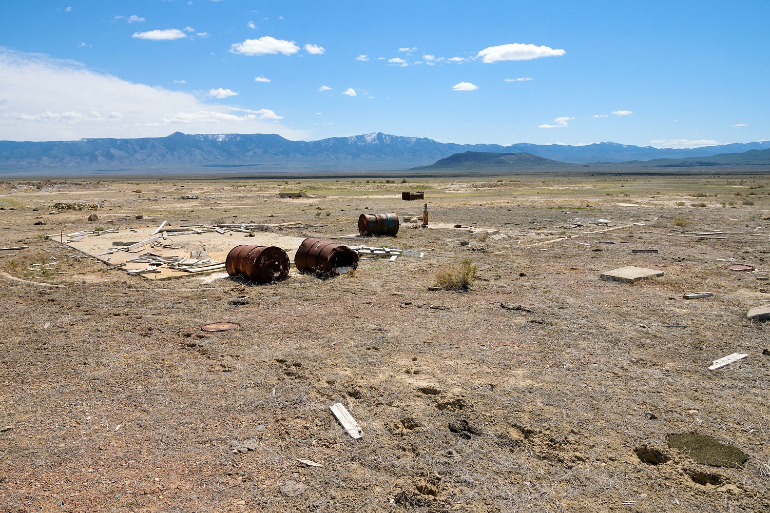
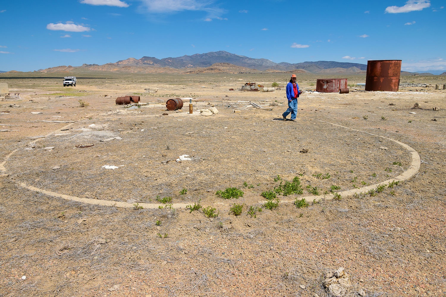
Buffalo Valley DOCILF and Beacon 32 (Airway light beacon, rotating) - 27 May 2017
From the Airway Bulletin no. 1-2. 1931-1938
"Buffalo Valley. - Department of Commerce intermediate field, site 32 San Francisco-Salt Lake Airway. Thirty-two miles SW. of Battle Mt., one-half mile SW, of Pearce Ranch. Altitude, 4,650 feet. Triangular, 3,420 feet in all directions, sod, level, natural drainage. Shed roof marked "32 SF-SL." Beacon, boundary, approach, and obstruction lights. Beacon, 24 - inch rotating, with green course lights flashing characteristic “1” ( . - - ). No servicing facilities."
This was an exciting site to explore. Although the beacon tower and generator shed are gone, the concrete pad and arrow are intact. Someone, recent to our visit, repainted the arrow in the original chrome yellow color.
This must have been a fairly developed intermediate airfield. There are foundations for buildings and machinery. A nice surprise was the decorative concrete curbs and walkways. It would be great to see historic photos of this site during its use, if any exist.
Satellite photos show the intermediate landing field as a large triangle - similar to the Humboldt DOCILF. Satellite photos also show concentric concrete circles at the center with a center dot. Hiking out the the center is on the "to do" list also.
Beacon Buffalo Valley Flats (auxiliary beacon, flashing) - 27 May 2017
This is another beacon site that is not shown on the Air Navigation Map but is indicated on historic USGS topo maps. This was our favorite beacon. Besides being mostly intact it was a very nice land navigation exercise. We used our map with a hand held compass and followed a bearing for 3.5 miles across the flats until the beacon tower came into view. We hit it dead on.
The complete light assembly atop the beacon tower was missing.
This was an acetylene fired beacon light. Very special here were the handwritten notes inside in pencil noting when tanks were changed out.
Beacon 334 (auxiliary beacon, flashing) - 16 April 2021
This beacon sits on a highpoint on the north end of the Fish Creek Mountains. It was around 2.5 miles, from where we parked the truck, up to the top. The views were incredible, especially with the changeable weather the day we were up there.
We found a few shards of the heavy glass lens.
There were several metals pieces painted with the distinctive orange paint.
We found where the beacon stood. It was anchored to the top with metal brackets into the rock, not with the anchor rods we found at most other sites.
All four corners had been broken or cut off.
Beacon East End of Buffalo Valley Flats (auxiliary beacon, flashing) - 16 April 2021
This is another beacon site that shows up on a 1932 USGS topo map but not on the Air Navigation Map. The remains of a service road leads to the site.
Not much remains at the site. We found one anchor rod and a crumbling concrete pad.
Beacon 339 (auxiliary beacon, flashing) - 29 May 2017
This beacon sits on the west side of the Reese River Valley and was another favorite of ours. It was another cross country hike following a compass bearing until the beacon came into view. Although the beacon tower is still standing, the acetylene powered light assembly is missing. Like many of the other standing beacons, it is used as a nest site. A couple week old pair of red tailed hawks greeted us at the beacon.
Tubing and controls for the acetylene remain in the base of the tower along with handwritten notes.
Beacon 33 (Airway light beacon, rotating) - a future search
From Air Commerce Bulletin Vol.2 No.15 Feb. 2, 1931
SF-SL site No. 33 — A 24-inch beacon light, 1,000,000 candlepower, showing 6 rotations per minute is in operation. Two red course lights flash characteristic: Dot, dot, dot (. . .). This beacon light is mounted on a 51-foot tower painted yellow and black. The power house shed at this site is painted black and yellow. The roof is painted yellow with black numerals and route designations.
This one is on the "to do" list. It sits somewhere along the Reese River. I'm still looking and researching at how to access the area - property ownership, location, and such.
Beacon 34 (Airway light beacon, rotating) - 16 April 2021
From Air Commerce Bulletin Vol.2 No.15 Feb. 2, 1931
SF-SL site No. 34 — A 24-inch beacon light, 1,000,000 candlepower, showing 6 rotations per minute, is in operation. Two red course lights flash characteristic: Dot, dot, dot, dot (....). The powerhouse shed at this site is painted black and yellow. The roof is painted yellow with black numerals.
This beacon is in the middle of the
Reese River Valley. It was a hike with wandering through sage and brush. We found
sections of the service road that once led to the location.
We found no evidence of the beacon - we will return to broaden the search area. We did find enough tantalizing clues to make us believe we were in the right place, especially evidence of old paint buckets with yellow and white paint.
I believe pilots had a choice after reaching Beacon 34. They could head northeast (10 miles) to the Battle Mountain DOCILF and Beacon 35.
Two auxiliary beacons are indicated as being in the Reese River Valley and I'm researching their probable locations -
Beacon 355 (auxiliary beacon,
flashing) - a future search
Beacon 361 (auxiliary beacon,
flashing) - a future search
Beacon 35 (Airport light beacon with code light) and Battle Mountain DOCILF - 29 May 2017
From the Airway Bulletin no.1-2. 1931-1938
"Battle Mountain. - Department of Commerce intermediate field, site 35, San Francisco-Salt Lake Airway. One-half mile SW. Altitude, 4,514 feet. Rectangular shape, 2,370 by 2,740 feet, sand, level, natural drainage. Entire field available. Shed roof marked “35 SF-SL.” Power line and buildings to NE Beacon, boundary, approach, and obstruction lights. Beacon, 24 - inch rotating, with green course lights, flashing characteristic "5" ( . . ). Emergency aviation gasoline."
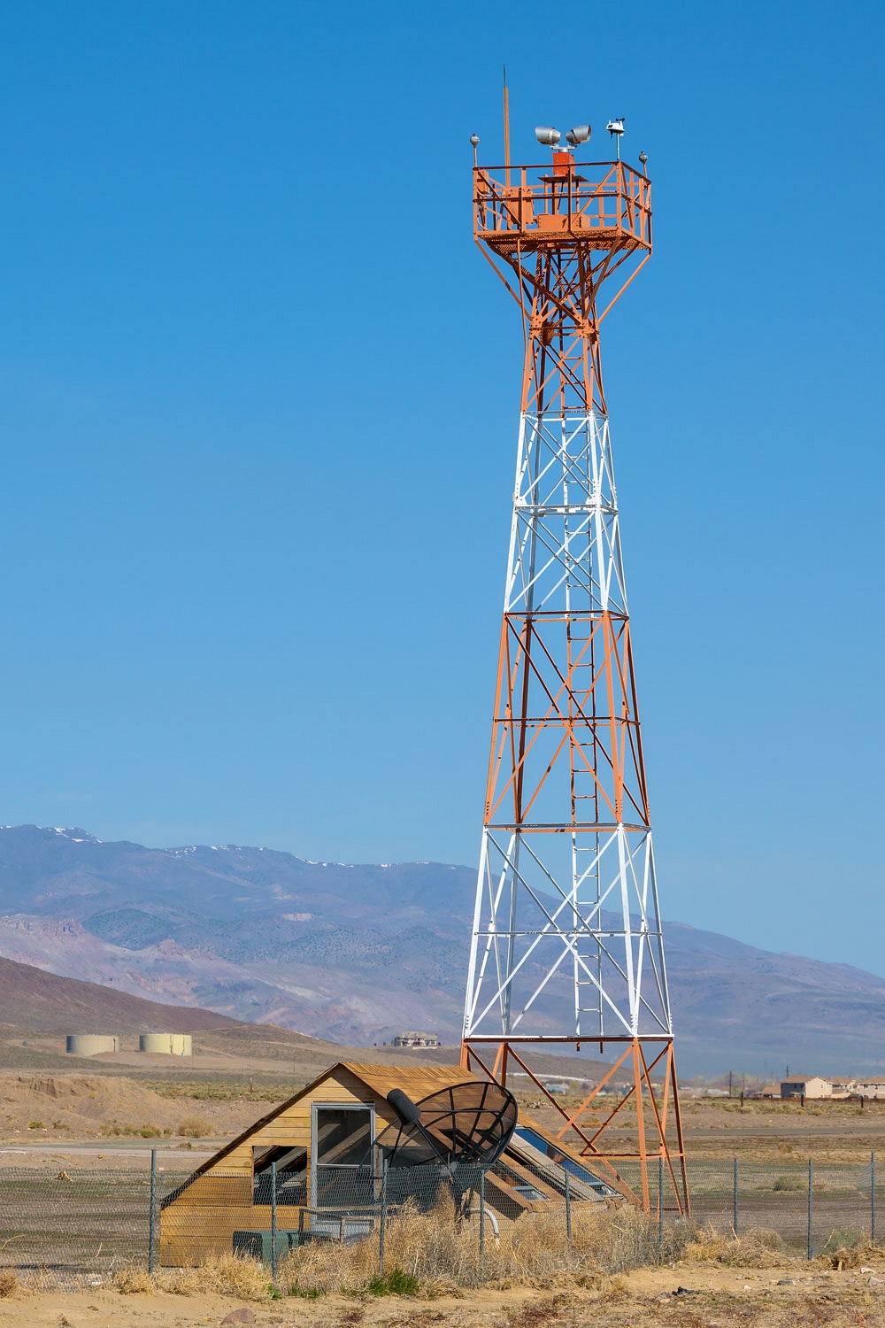
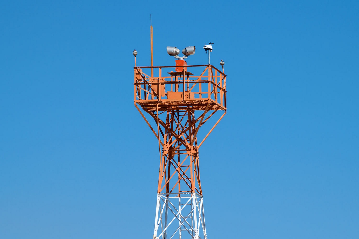
I believe the airport beacon was moved (Battle Mountain DOCILF was west of Battle Mountain) to the new Lander County Airport east of Battle Mountain. A few historic aircraft are on display at the base of the beacon tower.
The second choice for pilots at Beacon 34 was to fly east to Beowawe.
Beacon 367 (auxiliary beacon,
flashing) - a future search
This beacon site is atop the ridge between the Reese River Valley and Beowawe. Another on the "to do" list for us.
Beacon 37A (Airway light beacon, rotating) and Beowawe DOCILF - a future search
From the Airway Bulletin no. 1-2, 1931-1938
"Beowawe - Department of Commerce intermediate field, site 37B, San Francisco-Salt Lake Airway. Three miles W. on highway. Altitude, 4,695 feet. Rectangular shape, two runways, 3,950 feet E./W. and 2,650 feet NW./SE., sod, level, natural drainage; entire field available. Shed roof marked "37B SF-SL."
This one is also on the "to do" list. This site is just to the west of Beowawe. The airway rejoins the original route running east along the Humboldt River.
That's it. This is what we've found thus far. Our searches will continue. We love history. We love old fashion navigation. We love maps, especially historic maps. We love long hikes. This adventure fits well keeping us exercised, challenged, and happy. And it takes us through wonderful remote landscapes.
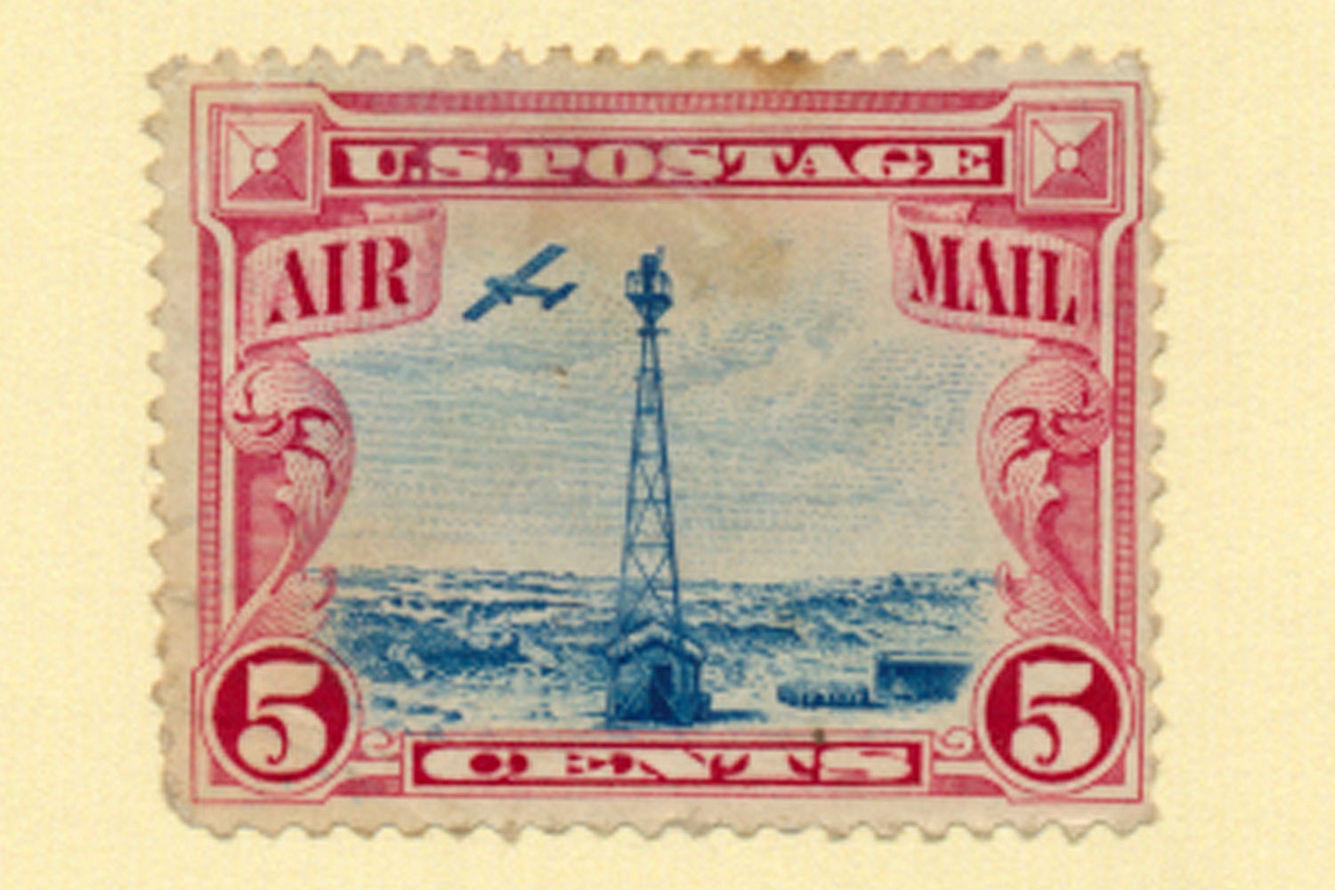
Our friend, Ted, as he followed our exploits searching for the air mail beacons presented us with a framed historic Air Mail postage stamp. It sits on the shelf above me as I type this. Thanks Ted!
An excellent source for information on U.S. Airmail beacons and routes can be found at this website -
Arrows Across America - Concrete Arrows, Beacons, and Airports
It's readily apparent a lot of hard work and research went into this website, the creators deserve much credit for their work.
I also found this from the U.S. Post Office -
Wonderful! Wonderful on so many levels. I really envy you this continual quest.
ReplyDeleteThank you for the very kind comment! Dusty, well used boots are the very best kind!
DeleteThanks Monte what a great "study" in the beacon system.
ReplyDeleteHad I known you about 15 years ago I would have had some early Air Mail
stamps for you.But the stamp collection was sold to get the Bobcat a few years later.
Keep posting more of this history.
Frank
Frank, thanks for your kind comment!
DeleteWow! What a thorough documentation. I can't imagine how many hours must have gone into this.
ReplyDeleteMany happy hours have been spent on research and boots on the ground searching. Thanks for the kind comment!
DeleteAnd soon enough, you'll both be back on the road, checking off the beacons on the "to do" list. Great write-up -- well done!
ReplyDeleteThis is David Lane in San Diego. I am so impressed with your passion for and dedication to airmail airway beacons.
ReplyDeleteMy first flight instructor at the Truckee Airport (50 years ago) passed away last year and I became the benefactor of his acetylene powered AGA airway beacon which he said was located near Fernley. He apparently acquired it in the mid-1960’s. If you email me, I would be happy to send you a photo. Thank you. InvaderLane19@aol.com.