
please remember you can click on a photo to see a larger version & highlighted text are links to additional information
Please click here for Part One
Part Two is authored by our friend the Sagebrush Reconnoiterer, a backcountry traveler, historian, and author. What follows is an exciting departure from our travel perspective to us being guided by Historian Intelligence. This was originally posted on the Wander the West forum and can be found - here. We have addition photos and narrative at the end.
The Hunt: A Single Day Snapshot of the Latest Ski3pins Adventure
by the Sagebrush Reconnoiterer
When Mr. & Mrs. ski3pins take a trip, I am among those privileged to follow along via nightly text messages on my phone from their InReach device. I often plot those on Google Earth on my computer; keeping tabs on their travels and safety for the duration of their trip.
As Monte has mentioned elsewhere on this forum and on his blog, I have at times in the past noticed that they were camped near a spot that held items that I knew would be of interest and have alerted them via a message back to their InReach and/or cell phone if I know that they have service; resulting in their curiosity getting the better of them and thus they go on a hunt. With rare exception, I refrain from giving them coordinates; instead subtle clues so that they can go and discover these gems for themselves. They love a good challenge!
Monte texted me today (April 23rd), asking if I would be interested in writing up a trip report of a single day of his current travels. So, in my best imitation of their excelling blog, EXPLORATION WITH THE SKI3PINS, here goes.
So, in the afternoon of this past April 21st, I received Monte's daily InReach “Camped here for the night” message. He and Julie were spending the night just west of the ghost town of Candelaria, Nevada, located in the west-central part of the state, south of Hawthorne.

A Google Earth view of the ski3pins campsite in relation to the townsite of Candelaria. The open wound on the land and the large scab north of it has decimated much of the town, though what is left is quite interesting and photographic; if you can manage to maneuver your camera's lens in a direction of undisturbed landscape. And away from the destruction, there are still subtle things to search for and are waiting to be found.
Over the decades since the early 1980s, I have visited the ghost town numerous times, watching more of it disappear with time and modern strip mining. Over the decades several aspects of the site have eluded me, in that I never took the time to search out locations of interest that I had discovered in word or print in between trips. In those decades, modern mining have removed the earth, roads, and remains here, and have dumped them over there, while burying roads and remains; thus these aspects will forever continue to elude me. Things such as Candelaria's close neighbor, Metallic City, the water pipeline to far off Trail Canyon in the White Mountains near the California border, and the town's water reservoir are things that I often wanted to find and examine but are still yet an unfulfilled desire of mine. Fortunately, modern strip mining missed digging up and burying Candelaria's history as a railroad town. Fortunately, on past visits, I have been able to fully explore and document the railroad terminus area. I last visited Candelaria was in the winter of 2006.
Being an abandoned railroad buff, I saw that Monte and Julie had parked their rig and set up camp not only atop the current maintained road at a summit west of the townsite, but also atop the former Carson & Colorado Railroad's Candelaria Branch. That railroad began life at Mound House, Nevada – near Virginia City – in 1880. It's narrow gauge rails began growing east, then south, then back west again; entering California, turning south again then terminating at Keeler, California in the southern Owens Valley southeast of Lone Pine in 1883. Along the way, a branch of approximately five miles was constructed to access Candelaria.
So, I naturally notified them of their plight. “You are 1,520 feet from the old C&C turntable pit. It's to your northeast.” I knew that especially Julie, naturally and intensely curious, would be jumping at the chance to check it out.
Since the Candelaria Branch was basically a dead-end street, the means to turn trains around was required. In the case of the Carson & Colorado Railroad, it mean using an “Armstrong” turntable to spin locomotives around to reverse their direction; the topography didn't allow enough room for a turning wye. Armstrong meant just that – locomotives were turned by hand on a pivoted, rotating platform. The depot and yard tracks are located at a summit in the Candelaria Hills, a mile and a quarter west of downtown. A stone supported shelf was built on the slope to hold the depot and ancillary structures, as well as sidings; tracks came to an end about four tenths of a mile beyond. Below the depot is the site of the turntable on its own spur; it's rock lined pit still visible, along with a well worn path for station hands to push the locomotive 180° so that it can pull out, then back in to the opposite end of the train to return to the mainline.

Google Earth view of the terminus, depot and turntable of the Candelaria Branch.
Not long after Monte and Julie set up camp, I began to notice on the forum that Monte was liking a few of the day's posts and made a couple posts himself; so I knew that he had cellular service and data. He also texted me phone to phone that he and Julie had just walked a portion of the railroad back down the hill toward the ghost town of Belleville, a milling center for Candelaria and along the main Carson & Colorado mainline. Along the way they came across a small diamondback rattler, who made sure that they noticed him with all his might. Just to be sure that he got my message about the railroad turntable pit – in case they had already put away their InReach device for the night before I originally responded – I sent him a regular phone text stating what I said in my InReach reply just as I turned in for the night.
At 0738 hours the following morning, I got a couple of photographs embedded in phone texts taken up on Candelaria Mountain during their morning coffee walk; one of them looking at their camper down below and inquiring if the railroad facilities were in the photo. The rest of the photographs posted here were taken by Julie with her phone camera.

Looking down on their camp. The railroad terminus facilities start at the extreme right center.

Later, while we were regularly exchanging texts with inquiries and answers, they dropped down from the heights down to the railroad and found the turntable pit.


In the bottom photo, the depot and yard tracks sat up on the level to the left. Note the flat path around the perimeter. Imagine the trestle stretched across the pit with a Baldwin locomotive sitting atop, two men on each side pushing against handles on the turntable to spin the locomotive.
Candelaria isn't one of those boom and bust ghost towns, it continued as a town and mining community well into the Depression. The Carson & Colorado, which was then under ownership of the Southern Pacific Railroad, finally abandoned the Candelaria Branch in 1932 and pulled up rails.
However, there was another gem for Monte and Julie to find, which I mentioned in my original reply to yesterday's InReach text.
“And the town's water reservoir, and the terminus of the pipeline from [T]rail [C]anyon is nearly due east of you and over the ridge.”

A Google Earth view looking northeast. The Hendricks' camp is noted at the left, the turntable pit nearby. Across the mountain to the right, and right of center, is the water reservoir for Candelaria. The straight road below is atop the pipeline from Trail Canyon.
Candelaria is in a fairly waterless region; local water
cannot sustain a booming and sizeable metropolis that Candelaria was turning
into during its heyday. So a 27 mile long water pipeline tapped springs in
upper Trail Canyon to convey water to a concrete reservoir located south of
town near what was once Metallic City. Trail Canyon is on the east side of the
northern White Mountains, near the California border. Monte and Julie have
several blog entries over the years about their times at the canyon in search
of native rock art. Fortunately, modern mining missed obliterating the
reservoir. While preparing this report, I found this webpage with information
about the pipeline and photos of what is left.
Candelaria Pipeline, Western Nevada
A game of textual volleyball continued throughout the morning, many asking for ideas as to how to access the reservoir. I texted them directions as well as screen shots from Google Earth from my desktop computer, which Monte also verified on his maps.
I also quipped: “This is the best that I can do without supplying the coordinates. Don't want to spoil the hunt.”
Earlier, Monte texted me a photo, taken atop Candelaria Mountain and looking south, and asking if it were the water pipeline. I responded: “It looks right. A scar running straight in an area where roads curve is a good indicator.” And then I added: “Instead of a pot of gold at the end of a rainbow, you will find an in ground reservoir at the end of a pipeline.”

The last part of the reservoir access road parallels the pipeline. Photos were taken.

Then two minutes later, these photos came, along with the words: “And the pot of gold. Thanks for the treasure hunt!”


The Candelaria town water reservoir and likely a related utility structure next to it.
About three hours later, I got another InReach message alerting me to their next campsite. I should have known that they would overnight at what I teasingly call their “second home,” as it's so prolific on their blog, the Benton Hot Springs Inn. Julie is so adept to finding cancellations that Monte calls her the "Tub Whisperer." A fine way to finish off a day of treasure hunting!
Or as Monte finished up the day: “We are always ready for more. Our hunting licenses are current.”
Additional information:
To get an idea of an Armstrong turntable, here is an intact one, located on the same railroad at Laws Railroad Museum, near Bishop, California. Laws is about an hour and a half south of Candelaria


It's design and operation is simple. A platform on a central pivot, upon which railroad rails are laid. Underneath at each end are small flanged wheels, riding along railroad rail laid around the perimeter of the pit. The locomotive and its tender (the car with wood, coal or oil to fuel the locomotive) is pulled onto the platform. Four men working in pairs grab onto a long handle on opposite sides, and push, turning the locomotive around. The locomotive is turned and can travel in the opposite direction.

A historic photo of the turntable at Laws in use. Photo from the Laws Railroad Museum website –
Turntable Laws Railroad Museum & Historical Site
The Southern Pacific Railroad filed for abandonment of the railroad between Tonopah Junction and Benton in 1933, not long after the Candelaria Branch was dismantled, and later removed the rails along the 50 mile route. Just after the United States entered World War 2, the Southern Pacific Railroad stopped service and abandoned the railroad line north of Laws; confining it to the 70 miles between Laws and Keeler. That line was the last operating narrow gauge railroad west of the Rocky Mountains. Southern Pacific abandoned and dismantled the railroad in 1960.
Below is the link to a documentary of the Carson & Colorado Railroad. It is comprised of amateur film movie footage of actual railroad operations on the line between Laws and Keeler, likely during the 1950s, the railroad's last decade of operation. Footage of railroad employees turning the locomotive on the line is found at the five minute mark. The entire video is 32:53 long.
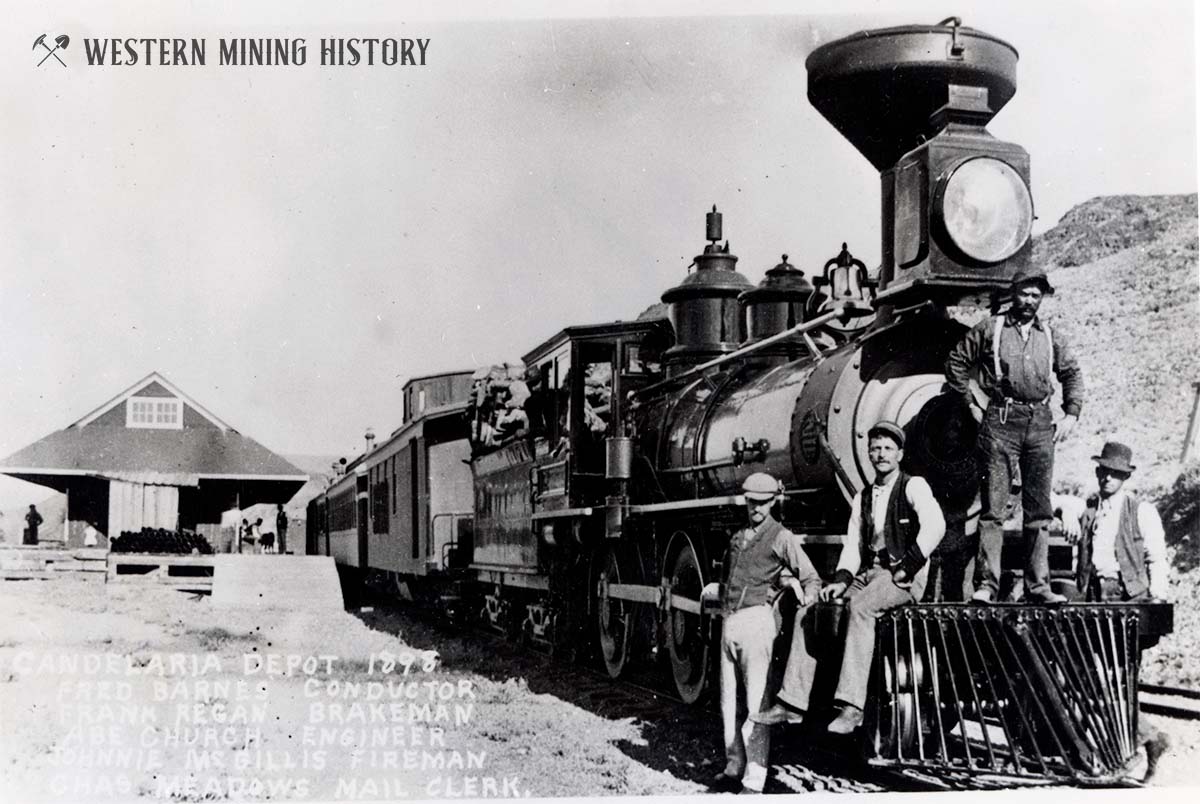
A nice view of a train at the depot in Candelaria.
A good historical overview of Candelaria, including more
railroad photos, here:
For those interested in the Candelaria water pipeline, I
found a second part to that in the original post about the pipeline and what is
there today. The person who posted it still didn't make it to Candelaria, but
has a better appreciation for the difficulty encountered by those who
constructed the pipeline.
Candelaria Pipeline………revisited
I picked up a copy of the book at the library in Winnemucca.

Some facts from Shamburger's book:
* The reservoir is, in fact the terminus of the pipeline from the White Mountains. It was 80'x90' and ten feet deep, for a capacity of "at least" 450,000 gallons.
* The remains of a structure is adjacent. This was used as an ice house.

* The original water line ran between what is now Pinchot Creek (originally called Pinschower prior to 1942); in later years more water was necessary for increased milling, so a line was run another four miles and tapped nearby Trail Canyon.
* Water reached the reservoir by February 25, 1882.
* In March of that year, crews were digging the ditch for a pipeline from the reservoir to Pickhandle Gulch. From there, water was distributed to several points in Metallic City and Candelaria. A few small reservoirs were built at the larger mines and reduction works.
* A line ran to the railroad yard and a storage tank was built and completed by the end of April, 1882.
* Residents of Candelaria and Metallic City were served by water wagons, making three round trips between the reservoir and town per day.
Kind of sad. Shamburger's book was published in 1978. Many of his own photographs are dated 1975. Both Candelaria and Metallic City contained numerous ruins. Photos of Pickhandle Gulch showed numerous dwellings and mine structures perched high on the slopes of the canyon. Using GE to look closely and move along what was Pickhandle Gulch as if on the ground really gives scale as to the destruction by open pit mining. Along the bottom half, the west side of the canyon has been removed and drops into the open pit. Along the upper half both sides have been removed; only a haul road is left to continue to once was the head of the canyon.
Ski3piners taking over. Thank you, Sagebrush, for the fun hunt and the excellent write up! And thank you for allowing me to post it again here. What is life without a series of treasure hunts?
Another memorable treasure hunt Sagebrush sent us on – when he noticed our InReach location – was April 2023.
He recalled a magazine article that mentioned a wagon left perched on the eastern slopes of the Panamint Mountains in Death Valley. Could we find it?


Continuing with our trip, after backtracking out of the Excelsiors, we crossed SR 360 and headed to the high saddle west of Candelaria. We know the area well and knew, most likely, we’d be alone.

We were also along the Carson & Colorado railroad grade. We walked it to the west and then returned to camp.

The little diamondback buzz worm that Sagebrush mentioned was pretty darn cute but would not pose for a photo. We did not push.
The early morning was glorious. Coffee was ready just as sun hit the camper.

For our morning coffee walk I was thinking we’d head further out the railroad grade toward Belleville. The Lady had another idea. “I want to go up there,” and pointed at a steep miner’s trail climbing up Candelaria Mountain. “Okay, if we don’t spill any coffee,” I offered, but she was already off.


The views were, of course, incredible. Here’s a view to the northwest with the road in from pavement and the C&C railroad grade to Belleville.

And a view to the northeast, similar to the cell phone photo the Lady shared with Sagebrush that started the hunt.

When she has cell service, the Lady greatly enjoys sending early morning coffee walk photos of expansive vistas to friends. Sagebrush’s response to her about a treasure hunt was like giving a shot of espresso to a hummingbird. But we were almost to the top of the ridge of Candelaria Mountain. We must continue up.

The more modern ruins of the Potosi Mine lay on the upper slopes.


Reaching the ridge top, we looked over the other side to the south and southwest. This includes the view of the Candelaria Pipeline and an expanding treasure hunt.


It was a quick return to our campsite. We had things to do!


We headed east on the C&C railroad grade toward the site of the depot and the adjacent turntable pit.

Our success is already documented above. Before heading around Candelaria Mountain in search of the pipeline and reservoir, we dropped down to what little remains of the old townsite of Candelaria.


The Lady was also texting with our friends Deb & Steve, the rubberlegs. Steve mentioned how much Deb enjoyed visiting the old cemetery. This prompted a revisit for us.

Can you imagine using a headstone for target practice? Yes, the marks are bullet strikes.

It is hard to fathom what a waste of oxygen some humans are; a reoccurring theme of these times. Other grave markers are in good shape and one has been uprighted since our last visit. Very nice.


This is the uprighted headstone.

The Chiatovich family grew to prominence in the area and the easiest access to Trail Canyon and the beginning of the Candelaria Pipeline – we’ve been there many times – is via Chiatovich Road.
This is my favorite headstone in the Candelaria Cemetery.

The A.O.U.W is the Ancient Order of United Workmen, a fraternal organization to benefit workingmen founded in 1868.
It was off to find the reservoir at the end of the pipeline on the opposite side of Candelaria Mountain. It was fun putting together the puzzle of faint, rarely used, roads to intersect with the Candelaria Pipeline. Sections of this route required four low.


The reservoir and the ice house.


Our successful treasure hunt was over. It was, indeed, a fun adventure. The forecast for afternoon storms over western Nevada continued. We hit rain over Montgomery Pass. Storm shrouded the northern White Mountains. Sagebrush, above, mentions the “Tub Whisperer” scoring a private campsite at Benton. Sadly, that was not quite accurate. We hoped to meet up with our friend, Donna, for a few days in Owens Valley. She had a night reserved at Benton for herself. Unfortunately, she had to return home and asked if we could take over her reservation – a benefit of cell service at Candelaria. An unexpected hot spring tub for the night was wonderful, but we were so looking forward to spending a couple of days with our friend.
The clearing storm at sunset was spectacular.


The restorative, healing waters worked their magic, as did the coming night.


The next morning, we headed into the high Sierra Nevada. Our adventure continues. Please click here for - Part Three.
No comments:
Post a Comment